
Your bag is empty
Don't miss out on great deals! Start shopping or Sign in to view products added.
Shop What's New Sign in£5.85 Save:£3.00(30%)
Available in stock
| Print length: | 64 pages |
|---|---|
| Language: | English |
| Publisher: | Collins |
| Publication date: | 2 Mar. 2023 |
| Dimensions: | 20.4 x 0.81 x 29.21 cm |
| ISBN-10: | 0008597677 |
| ISBN-13: | 978-0008597672 |
 Invincible Compendium Volume 2 (INVINCIBLE COMPENDIUM TP)
£35.41
 The New GCSE Arabic Companion (9-1)
£23.75
 Of Mice and Men (New Longman Literature - Plain Edition)
£2.92
 The Red Rising Series Collection 5 Books Set By Pierce Brown (Red Rising, Golden Son, Morning Star, Iron Gold, Dark Age)
£18.67
 Dead Girls Don't Talk - Amazon Exclusive Edition: A YA thriller about a murdered girl, but if you flip over the book you can read from the killer's POV.
£12.54
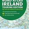
Explore Ireland with this accurate and fully updated road atlas. This road atlas is at A4 size, covering the whole of Ireland and features clear and detailed Collins colour mapping at a scale of 5.2 miles to 1 inch. Perfect for both residents and visitors touring Ireland. This revised edition includes: Places of tourist interest Contact information for Tourist Information Centres with grid references to the mapping Fully indexed street maps of 11 cities and towns – Dublin, Belfast, Cork, Limerick, Waterford, Londonderry (Derry), Galway, Bangor, Dun Laoghaire, Drogheda and Killarney Blue Flag & Green Coast beaches Ferry and airport information; Distance chart; Distances marked on the roads in miles and kilometres Route planning map of the whole of Ireland at 15.8 miles to 1 inch Administrative map of Irish counties and districts. – ASIN: 0008597677 | ISBN13: 9780008597672 | ISBN-13: 978-0008597672
You must be logged in to post a review.


Reviews
There are no reviews yet.